About the water levels of Lake Prespa
The text that follows does not express the personal opinion of MES, but rather constitutes a synthesis of all available literature to which we have access, produced through numerous geological, hydrological, and biological studies in the region.
Seasonal and multiannual changes in the water level of Lake Prespa result from variation in:
[1] the inflow of water from rivers and groundwater;
[2] the amount of precipitation;
[3] the rate of evaporation from the lake; and
[4] the volume of water used for irrigation.
The first three factors reflect the average climatic conditions in the lake’s catchment area, since all river flows and groundwater are replenished by precipitation within the basin, i.e., its steep watershed. On the other hand, lake water has been used directly for irrigation, and indirectly through the extraction of groundwater via wells in all three countries since the 1950s. The karst outflow of the lake through Mount Galičica into Lake Ohrid is also often mentioned as a factor, yet it has been established that its volume remains stable when the water level fluctuates between 842–852 m above sea level (up to 50% of the water in the springs at St. Naum and Tushemisht in Albania originates from Prespa and contributes around 25% of the total volume of Lake Ohrid). The geomorphology of the region itself does not allow water levels higher than 853 m, as in such a case the lake would begin to overflow into the southern part of the Korçë Basin. This is likely not a significant factor, as no correlation has been found between lake level fluctuations and the occurrence of earthquakes that might alter the volume of karst outflow through physical changes in the channels beneath Galičica (Schriek & Giannakopoulos 2017a).
Of the four factors mentioned, evaporation stands out as a key one, as it functions as a natural buffering system that mitigates fluctuations. The rate of evaporation depends directly on the surface area of the lake, which in turn varies with changes in water level. Thus, at lower water levels the lake’s surface area is reduced, and consequently the area available for evaporation decreases. In this way, water loss is partially compensated by the inevitable reduction in evaporation as the lake level drops. Using data from all three countries, van der Schriek and Giannakopoulos (2017a) attempted to determine to what extent changes in evaporation, and thus water level, are attributable to the factors outlined above.
The results are complex and must be considered on two levels: seasonal and multiannual. Seasonal changes in water level attract the greatest attention, as they are abrupt and most visible, and therefore seemingly the most alarming. Multiannual changes, by contrast, result from subtle, seemingly insignificant variations whose cumulative effect may be considerable.
Seasonally, the most important factor is average climatic conditions, best reflected in precipitation. However, caution is required when interpreting averages. If we compare two different periods: 1952/53-1977/78 and 1978/79-2003/04, we do not observe significant differences in average annual precipitation. Yet, when these values are narrowed to the so-called “wet period” in Prespa (October–April), a clear trend emerges in the latter period: a marked decrease in precipitation year by year and an increased frequency of dry years. Significant seasonal increases and decreases in lake volume have been shown to result primarily from increased precipitation, as in the “wet season” of 1962–63, or from severe droughts, as in 1974–78 and 1987–95 (Figure 1). Precipitation across the Mediterranean region depends on a global climatic phenomenon caused by interactions between the Atlantic Ocean and the atmosphere, known as the North Atlantic Oscillation. Nevertheless, this does not absolve humans of responsibility, as human activities significantly contribute to global climate change.
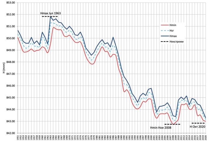
Figure 1. Changes in the water level of Lake Prespa from 1951-2020 (Source: UHMR)
Multiannual changes in water level point to a different conclusion. While the difference in water level between October 2019 and October 2020 is directly related to precipitation in the Prespa basin between October 2019 and March 2020, the long-term decline since 1951 is due to another factor. Research by van der Schriek and Giannakopoulos (2017a) indicates that, cumulatively since 1951, irrigation is the primary “culprit” behind reduced lake levels, accounting for 70% of the loss, while reduced precipitation accounts for only 30%. The annual volume of water used for irrigation appears modest—just 0.003–0.006% of the total lake volume—but its cumulative effect over decades is substantial. At the same time, numerous studies indicate that climate change will lead to a progressive decrease in precipitation across the Mediterranean and an increased frequency of drought years. Lake Prespa and Lake Ohrid, together with Mediterranean islands, are identified as among the most vulnerable systems to these future changes, suggesting that seasonal fluctuations in water level are likely to evolve into long-term trends (Markovic et al. 2017).
As part of a complex geological system that responds rapidly to seasonal climatic changes, Lake Prespa has most likely experienced major fluctuations even before the period for which written records exist.
Evidence for historical changes in water level is provided by geological and paleoecological studies examining hydrogen and oxygen isotopes, as well as fossilized pollen from past vegetation extracted from lake sediments. During the Holocene (the last 10,000 years), the Prespa–Ohrid region, like the wider Mediterranean basin, experienced relatively stable annual precipitation (Leng et al. 2013), but this changed around 1,000 years ago. Changes in isotope dynamics and fossil pollen indicate a lower water level, which is particularly noteworthy as it coincides with archaeological sites dated to the late 10th and early 11th centuries. These structures are located at elevations of 840–842 m above sea level (Sibinović 1987), corresponding to the lowest recorded levels of the lake today.
Additionally, Eftimi (2019) mentions the construction of a road or dam near the village of Dolna Gorica in Albania, where the largest known sinkhole through which Lake Prespa drains via Galičica is located (Figure2).
The author suggests that this may represent further evidence that the lake can naturally reach low water levels - a phenomenon that local populations may have attempted to manage by constructing a barrier to prevent outflow and secure a stable fish supply.
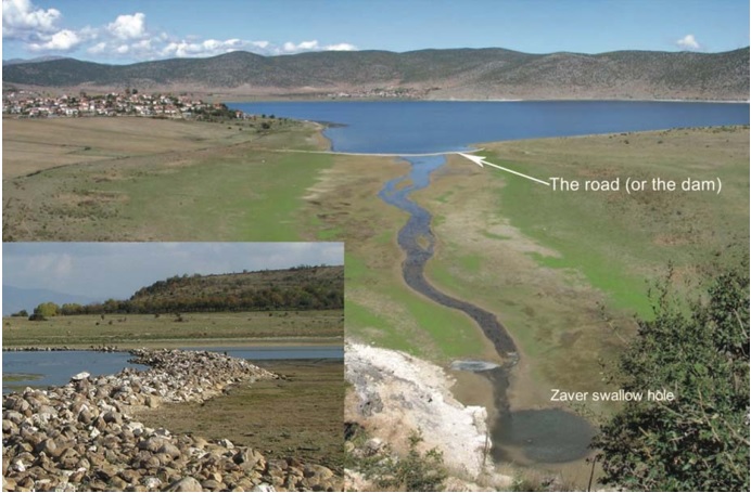
Figure 2. The “dam” in front of the Zavir Abyss near the village of Dolna Gorica in Albania, visible only at low water levels. Source: Eftimi 2019[6]
The complexity of these conditions makes it difficult to develop reliable predictive models of water level changes in Lake Prespa. It must be acknowledged that even the findings presented here rely on scientific research based on numerous data sources whose collection is rarely standardized and is subject to error. For example, there are no unified datasets on water used for irrigation, which must therefore be reconstructed from written and even oral reports, as well as indirect estimates. Meteorological data are more standardized, but still incomplete: weather stations are located at 850–1,000 m above sea level, while high-mountain areas (up to 2,400 m) account for more than 60% of the catchment. In North Macedonia, there is no registry of wells in the region, while the Lake Prespa management plan estimates their number at 8,000–10,000. Moreover, there is no systematic monitoring of changes in cultivated land along the lakeshore.
Nevertheless, the precise origin and function of the dam/road remain unknown. The most comprehensive studies of Lake Prespa’s water level over the past 1,500 years have been conducted by Schriek and Giannakopoulos (2017b), who analyzed sediments beneath the Kula site, a land isthmus between Great and Small Prespa Lakes in Greece. Their findings indicate that around the year 700, the lake had a high water level corresponding to a cooler climatic period in the southwestern Balkans between 500 and 900. Reduced evaporation and increased snow cover in the mountains contributed directly to this high level. This was followed by the lowest recorded levels during the dry period between 900 and 1300/1450, known globally as the Medieval Climate Anomaly, when the lake level was similar to today’s (around 845 m). The driving factors were likely similar to those today, but without intensive human use of water for irrigation. A subsequent cooling period—the Little Ice Age (1650–1840)—brought increased humidity that persisted until the 1980s. Notably, studies of fossil diatom communities in Lake Prespa fully corroborate these findings (Cvetkoska et al. 2014). It appears that even without significant human intervention, this complex geological system renders the lake particularly susceptible to major fluctuations in water level. However, this does not mean that human influence is negligible. On the contrary, in addition to the dry period since 1980, continuous water extraction has further intensified this semi-natural phenomenon.
Beyond dependence on lake water, everyday human activities in its immediate vicinity enrich the system with both inorganic and organic substances. This process, known as eutrophication, forms part of the natural ageing of the lake, but is significantly accelerated by human activity. The reduction in water volume further accelerates this process, as the same quantity of nutrients in a smaller volume results in higher concentrations. Monitoring indicates that water quality falls within a moderate classification under the EU Water Framework Directive, while trophic analyses classify the lake as mesotrophic to eutrophic.
All these factors, along with many others, are essential for producing accurate assessments and predictions of future fluctuations in the lake.
The transboundary nature of the region further complicates the situation, which is why the first step toward addressing this complex issue is urgent coordination among the three countries through a functional transboundary body within the “Prespa Park,” composed of representatives from all three states. As a priority, it is necessary to establish regulations and shared databases for cross-border data collection involving all relevant stakeholders.
The lesson is clear: both natural and human-induced climate changes, as well as direct water use for human needs, contribute to fluctuations in the water level of Lake Prespa. All of us must reflect more frequently and responsibly on our everyday actions and recognize that no action occurs without consequence. Irresponsible behavior—from improper waste disposal to the destruction of wetlands and other habitats that still sustain the lake—will inevitably come at a cost, in this case through shorter, milder springs and long, dry summers marked by relentless heat to which Lake Prespa is not adapted.
Throughout its long geological history, life has adapted to climatic and environmental changes, but humans have been part of that living world for only a very brief span (300,000 years compared to nearly 4 billion years). In that short time, we have built societies dependent on stable ecosystems, yet in doing so we have also altered them, producing consequences that are global and already evident. The current question of saving Lake Prespa is not only about preserving its unique natural and cultural values, but also about safeguarding the way of life we have built within this system. Ultimately, it is the only way we know how to survive.
[1] Schriek, T. van der, & Giannakopoulos, C. (2017a). Reconstructing absolute water-level variability of Lake Prespa (SW Balkans) during the Medieval Climate Anomaly and ‘Little Ice Age’ from a prograding beach ridge complex: The Holocene. https://doi.org/10.1177/0959683617708449
[2] This depends on the bathymetry of the lake, i.e. the relief under the lake water. For example, during the first known drop in water level, Lake Prespa did not experience a significant drop in the surface of the lake water, and thus evaporation, simply because of the steep relief, especially on the side of the Galichica mountain. Bathymetric maps indicate that with a continued drop in level, a steepening of the underwater relief soon follows, i.e. the maintenance of a similar lake surface despite the reduction in the water column, and thus further accelerated water loss.
[3] Markovic, D., Carrizo, S. F., Kärcher, O., Walz, A., & David, J. N. W. (2017). Vulnerability of European freshwater catchments to climate change. Global Change Biology, 23(9), 3567–3580. https://doi.org/10.1111/gcb.13657
[4] Leng, M. J., Wagner, B., Boehm, A., Panagiotopoulos, K., Vane, C. H., Snelling, A., Haidon, C., Woodley, E., Vogel, H., Zanchetta, G., & Baneschi, I. (2013). Understanding past climatic and hydrological variability in the Mediterranean from Lake Prespa sediment isotope and geochemical record over the Last Glacial cycle. Quaternary Science Reviews, 66, 123–136. https://doi.org/10.1016/j.quascirev.2012.07.015
[5] Sibinović, M. (1987). Ezera Prespansko i Ohridsko. The SRC & Agency of Water Resources of R. of Macedonia, Skopje.
[6] Eftimi, R. (2019). The catastrophic decrease of Prespa Lake—Result of natural or anthropogenic reason? Review of the Bulgarian Geological Society, 80, 215–217.
[7] Schriek, T. van der, & Giannakopoulos, C. (2017b). Reconstructing absolute water-level variability of Lake Prespa (SW Balkans) during the Medieval Climate Anomaly and ‘Little Ice Age’ from a prograding beach ridge complex. The Holocene, 1–11. https://doi.org/10.1177/0959683617708449
[8] Cvetkoska, A., Levkov, Z., Reed, J. M., & Wagner, B. (2014). Late Glacial to Holocene climate change and human impact in the Mediterranean: The last ca. 17ka diatom record of Lake Prespa (Macedonia/Albania/Greece). Palaeogeography, Palaeoclimatology, Palaeoecology, 406, 22–32. https://doi.org/10.1016/j.palaeo.2014.04.010
[9] Nutrients are introduced into the food webs that make up the ecosystem (e.g., phosphates -> plankton -> small invertebrates -> fish). More nutrients can support more life, which means more organic matter is created, which will decompose and/or eventually settle to the lake bottom. This process uses up oxygen, which can lead to anoxic conditions, and can also foul the lake from within.
[10] PSI Hydrobiological Institute – Ohrid. (2016). Lake Prespa Monitoring Report 2013-2016 (Macedonian Part) (p. 131) [Draft].
[11] Kaplan, G. (2020). Monitoring Changes in the Prespa Lake Watershed Using Remote Sensing Data. European Journal of Geosciences, 2(2), 15–23. https://doi.org/10.34154/202-EJGS-0202-15-23/euraass